


This article describes how plots, tracks and labels are displayed in PPIs for airtraffic control in compliance with ICAO Doc 4444. All features are part of SkyRadar's FreeScopes ATC module.
Plots
Plots are target reports that are created from the digital integration of received echoes (PSR) or replies (SSR) within the antenna beamwidth. The PSR report includes range and bearing information. The SSR report contains a Mode 3/A identity code and the Mode C decoded altimeter height value.
A plot extractor is used to obtain the plots from surveillance data. This is a device or algorithm that processes raw data from a surveillance sensor. The plot extractor must distinguish target data (aircraft) from:
- Weather clutter, like clouds or precipitation
- Ground clutter, like (buildings or terrain)
- Noise, both internal and external
- Other objects, like flocks of birds
The type of plot (primary/secondary/combination) depends on the sensor it comes from. Primary plots come from a Primary Surveillance Radar (PSR). Secondary plots come from an Secondary Surveillance Radar (SSR). Combined plots are when a primary and a secondary plot come from the same aircraft.
Primary plots provide 2-D position information unless the radar can determine the targets’ level. SSR code and aircraft level are added by secondary plots if Mode C data is available.
Tracks
A track is a target report that is created by a special tracking algorithm of a stream of radar-reported positions for a single aircraft. Smoothed position and speed vector information are typically shown in the report.
Depending on the sensor used, tracks can be primary, secondary, or combined. Depending on the number of sensors used, tracks can be mono or mult-iradar, which is more accurate because tracks are sent from different sensors and then averaged to create a single track.
Tracks provide additional information, like:
- Machine speed (available for all tracks)
- Vertical speed (secondary tracks only)
- History (available for all tracks)
- Predict vector (available for all tracks)
ATM procedures are often dependent on the sensor that provides data for a particular track. Because of this, different symbols are used to represent the individual tracks.
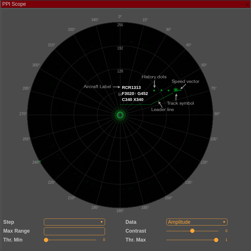
Labels
Both plots and tracks can have labels. However, plot labels do not contain as much information as track labels do. Track labels that are correlated with a flight plan contain more information and are more interactive. Additionally, Controller Pilot Data Link Communications (CPDLC) is usually performed on the fields found in the correlated label.
Labels include:
- Aircraft label
- Speed vector
- Leader Line
- Track Symbol
- History Dots
It is possible to move labels around so that they do not overlap and become difficult to distinguish. There are some systems that have an automated decluttering feature that will try to rearrange the labels without input from the controller.
While label contents depend on the ATS system design, there are still some common principles that are followed:
- Labels must be concise meaning containing all vital information, but not being superfluous in the process. Often, the solution for this is to have two versions of the label, a simple label with basic information and an extended label with full information.
- The most commonly used label shape is a rectangle that consists of between 2 to 5 rows. Each row can contain one or more data fields.
- Essential procedure-related information is often included in a label, such as:
- Aircraft RVSM status
- RNAV capability
- Wake turbulence category
- ICAO Doc 4444 requires that:
-
- The label includes information that relates to the aircraft’s identity, like its SSR code or call-sign.
- The label must display level information when available.
- Labels are connected with their position indications in a way that makes it easy for the controller to know which track the information refers to.
- SSR codes are not always visible at all times. However, when emergency codes 7500, 7600, and 7700 are used, they must be displayed or by a short warning message above the aircraft label.
- Correlated labels can be used in different colors that will help the controller build and maintain situational awareness.
- Labels for flights on the frequency typically have interactive fields that controllers can use to store and retrieve information.
SkyRadar's FreeScope ATC module
With the FreeScopes ATC module, you can experiment on tracking on SkyRadar's NextGen 8 GHz modules. Various filters like the Kalman filter, Alpha beta algorithm, or the Alpha beta gamma algorithm can be applied.
Contact us to learn more about the SkyRadar hands-on training radars for ATC-Academies and Universities.

References
Plots, Tracks and Labels (retrieved May 2020), by Skybrary